Region of the Aegean Plate and Adjacent Areas
The wider region of the Aegean Plate experienced an unprecedented increase in seismic and volcanic activity in 2025, significantly exceeding historical records and signaling potential fundamental changes in the tectonic and volcanic regime of the area.
The number of earthquakes with a magnitude of M 4+ in this region in 2025 exceeded 500, representing more than a doubling compared with the typical average of 200–250 events per year (Fig. 1–2).
The Aegean Plate region is among the best seismologically monitored areas of the Mediterranean, and earthquake catalogs in this region have been reliable for earthquakes of approximately M4+ since the 1980s–1990s.1
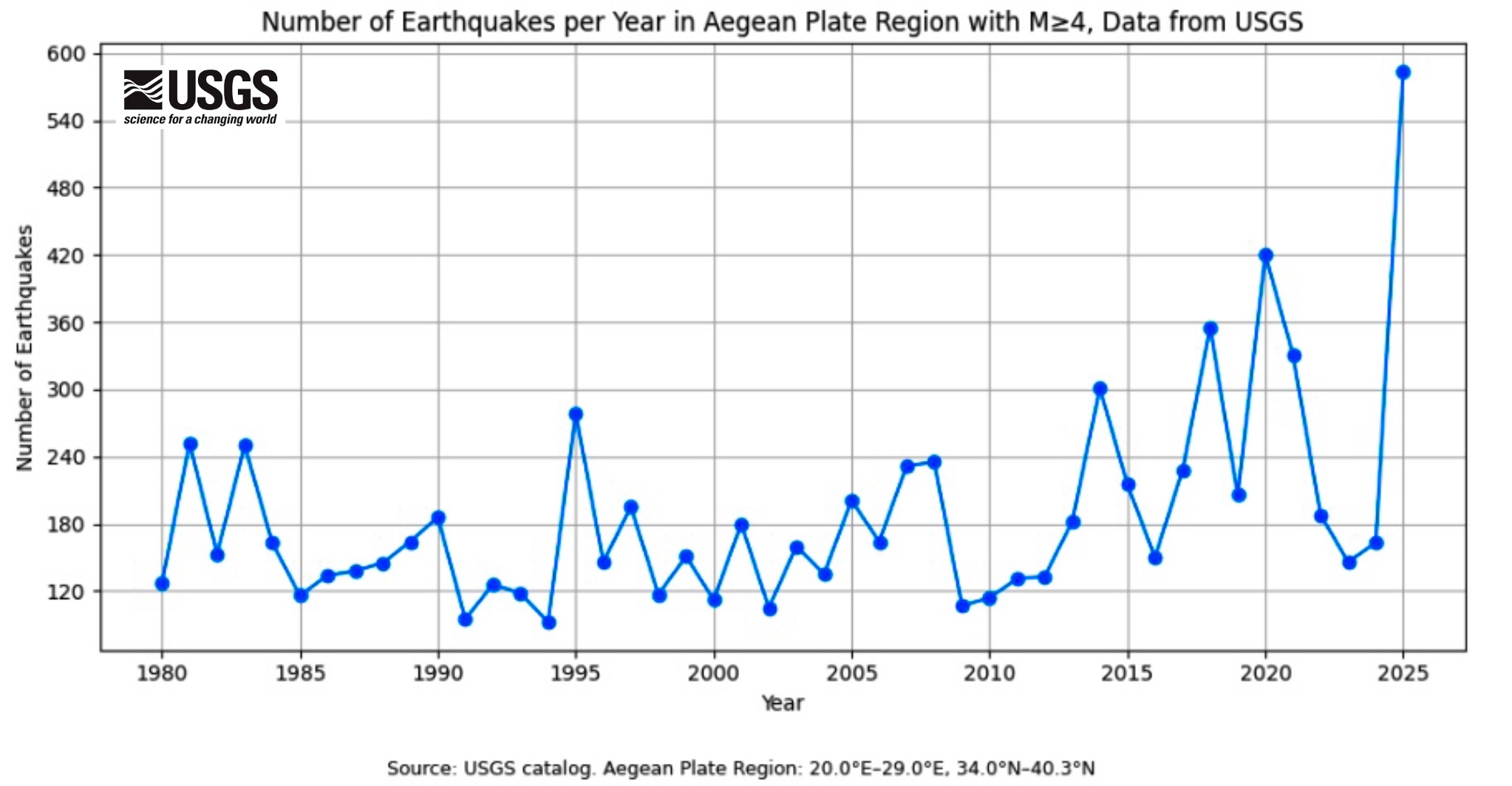
Fig. 1: Number of earthquakes with M ≥ 4 in the Aegean Plate area, data: USGS: https://earthquake.usgs.gov/earthquakes/search/
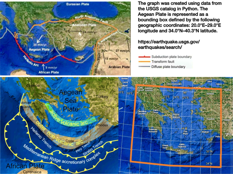
Fig. 2: Analyzed zone of the Aegean Plate, sources: https://www.keeptalkinggreece.com/2020/01/25/turkey-earthquake-greece-lekkas/ (top left), https://fr.wikipedia.org/wiki/Arc_%C3%A9g%C3%A9en#/media/Fichier%3AHellenic_arc.png (bottom left), Google Earth, custom edit (bottom right)
This region is part of the Aegean–Anatolian deformation belt, where three tectonic plates meet: the Aegean Plate, the Anatolian Plate, and the African Plate.
The Aegean volcanic arc is one of the most active tectonic-volcanic zones in Europe. This process is responsible for the existence of several volcanic systems:
Santorini–Kolumbo (the most famous and most active)
Nisyros – active hydrothermal activity2 , last eruption about 24,000 years ago3
Methana – active fumaroles and hot springs4
Milos – extensive surrounding hydrothermal activity5
The increased seismic activity in 2025 suggests the reactivation of this volcanic arc.
The Aegean Plate has a thinner crust than continental regions—crustal thickness here reaches only 25–30 kilometers compared with 35–40 kilometers in stable continental regions6. This thinner crust means that the region responds more quickly to changes in deeper processes within the Earth.
The Earth’s crust here is constantly stretching, fracturing, and subsiding, producing numerous earthquakes and also relating to volcanic activity. The rate of extension reaches 3–4 centimeters per year in some areas, which is a geologically very rapid process.7
The Aegean Plate may function as a “seismic indicator” of deeper mantle processes, reacting first to changes that may later manifest in other regions.
Santorini: An unprecedented seismic swarm and magma movement
Santorini (ancient Thera) is one of the most famous volcanic systems in the world and is also known for its dramatic geological history.
The largest known eruption of Santorini occurred around 1600 BCE (the precise dating is debated) and reached level 7 on the VEI scale. This so-called Minoan eruption produced approximately 60 cubic kilometers of volcanic material and created the present caldera. The eruption triggered massive tsunamis that affected the entire eastern Mediterranean. Many researchers link it to the collapse of the Bronze Age Minoan civilization on Crete.
At the beginning of 2025, scientists recorded an unprecedented earthquake swarm in the Santorini area which, according to a study from the University of Oregon, was related to magma movement beneath the volcano8. While normally almost no earthquakes of magnitude 4 or higher occurred at Santorini, this year there were more than 350 according to the USGS database (Fig. 3).
A study using advanced seismic analysis revealed that the earthquakes were not caused solely by tectonic processes but that magma was moving within underground chambers beneath the caldera. This magma movement generated pressure that manifested as a series of earthquakes.
Greek and international volcanological teams recorded9:
A dramatic increase in seismic activity
Ground deformation (GPS measurements showed slight uplift of the central part of the caldera)
Increased emissions of volcanic gases from submarine fumaroles
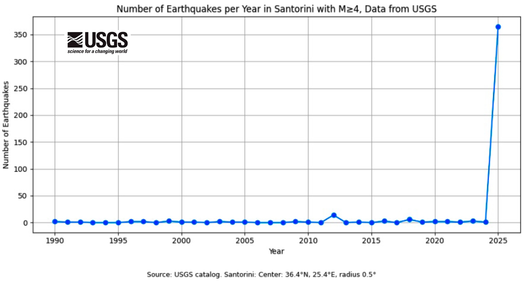
Fig. 3: Number of earthquakes with magnitude 4 or higher around the Santorini caldera, data source: USGS https://earthquake.usgs.gov/earthquakes/search/
Kolumbo: A Growing Magmatic Chamber Beneath the Sea
Approximately 7 kilometers northeast of Santorini lies the submarine caldera Kolumbo—the most active submarine volcano in the Santorini area. This caldera is about 3 kilometers wide and 500 meters deep. It formed during the last major explosive eruption in 1650, accompanied by massive tephra emissions.10
Submarine robots and oceanographic expeditions in 2025 recorded:11
New fumaroles (submarine vents emitting volcanic gases) around Kolumbo
Increased seafloor temperatures (locally up to 10–15°C higher than the surroundings)
Anomalies in the chemical composition of seawater indicating the leakage of volcanic gases (CO₂, SO₂, H₂S)
Seismic activity beneath the seafloor related to magma inflow
New research has shown that beneath the Kolumbo volcano there is a large magmatic chamber that has gradually expanded since the last eruption in 1650. Scientists used the method of full-waveform inversion, an advanced seismic technique analyzing the entire course of seismic waves, allowing them to create a detailed three-dimensional image of the magmatic system beneath this submarine volcano.
They found that beneath the caldera there exists a large zone of partially molten rock or magma located approximately 2 to 4 kilometers beneath the seafloor. The volume of magma in this chamber is gradually increasing as new magma continuously rises from greater depths, meaning the entire system has been filling for approximately 375 years since the last major eruption.12
Scientists warn about the possibility of a tsunamigenic eruption, as activity within the magmatic chamber could lead to an extremely explosive development. If magma comes into contact with seawater, its explosivity increases dramatically. Submarine eruptions represent a specific risk - hot magma with temperatures of approximately 800 to 1200 °C, when coming into contact with water, causes rapid vaporization, leading to so-called phreatomagmatic explosions, considered the most explosive type of volcanic activity.13
The pressure generated by the sudden evaporation of huge quantities of water can result in extremely powerful eruptions, the formation of massive tsunamis when the water column above the eruption site suddenly rises and generates destructive waves, and the production of large amounts of fine volcanic ash that could disrupt air traffic across Europe.
Historical records from the 1650 eruption of the Kolumbo volcano describe ships sailing through “boiling seawater,” pumice falling hundreds of kilometers from the explosion site, and enormous quantities of volcanic gases escaping into the atmosphere. The consequences were tragic - approximately 70 people died on nearby islands.
The combination of activity at Santorini and Kolumbo is particularly concerning because it suggests that the entire volcanic system of the southern Aegean Sea is undergoing a phase of reactivation. Some studies suggest that both calderas may be connected to a common deep magmatic reservoir, meaning that activity in one may influence the other.14
Fault Line of Western Turkey and the Aegean Sea
Along with the Aegean Plate, neighboring Turkey—specifically the region of western Turkey—has also experienced a dramatic increase in activity.
In 2025, five earthquakes with magnitudes above M 6 occurred in the region of western Turkey and the Aegean Sea, something that has not happened at least since 1950 (Fig. 4–5):
April 2025: M 6.2 near Istanbul
May 2025: Two M 6+ earthquakes near Crete (Greece)
August 2025: M 6+ near Balıkesir (Turkey)
October 2025: M 6+ near Balıkesir (Turkey)
The concentration of five strong earthquakes within a single year in a relatively small geographic area is extremely unusual and suggests significant changes in the distribution of tectonic stress.
Particularly concerning are the two M 6+ earthquakes in September and October near Balıkesir, which occurred in the area of the Western Anatolian Fault—a zone where the Western Anatolian Plate meets the Aegean Plate.
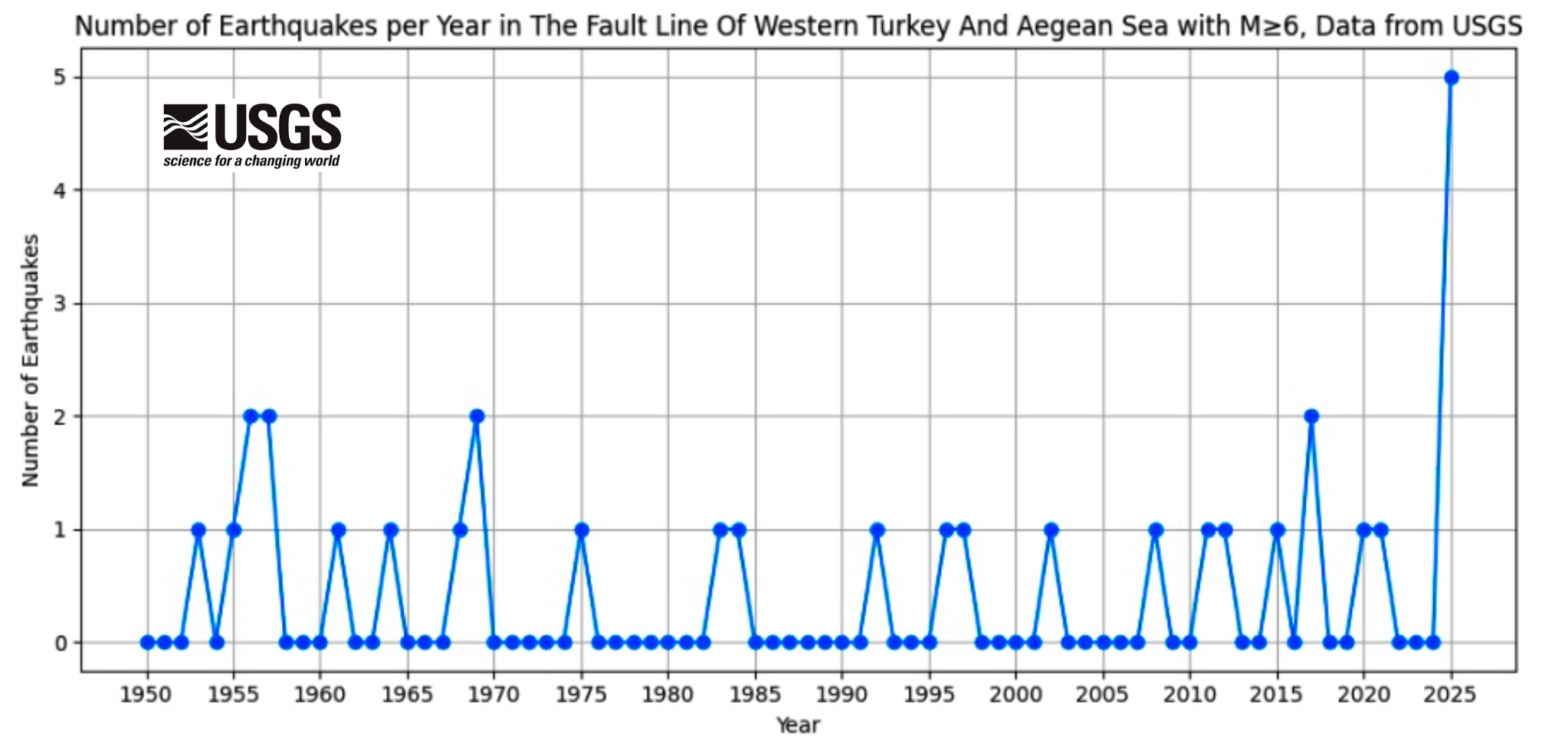
Fig. 4: Number of earthquakes with M ≥ 4 in the area of the western Turkey–Aegean Sea fault line, data: USGS https://earthquake.usgs.gov/earthquakes/search/
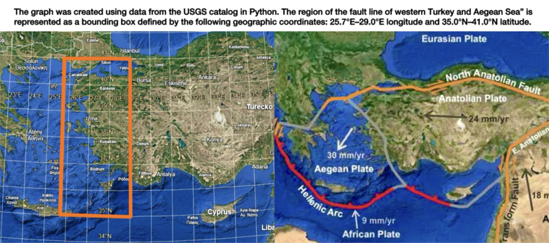
Fig. 5: Analyzed zone of the western Turkey–Aegean Sea fault line, sources: Google Earth, own modification (left), https://www.keeptalkinggreece.com/2020/01/25/turkey-earthquake-greece-lekkas/(device)
Resources:
Sparacino, F. et al. (2022) “Seismic coupling for the Aegean - Anatolian region,” Earth-Science Reviews, 228, p. 103993. Available at: https://doi.org/10.1016/j.earscirev.2022.103993.
Nisyros: The volcanic craters in the Nisyros caldera. Available at: https://nisyros.de/en/geology-of-nisyros-volcano/the-volcanic-craters-of-nisyros (Accessed: March 16, 2026).
Antoniou, V. et al. (2021) “Nisyros Volcanic Island: A Geosite through a Tailored GIS Story,” Geosciences, 11(3). Available at: https://doi.org/10.3390/geosciences11030132.
“Methana Peninsula” Visit Attica. Available at: https://athensattica.com/point/methana-peninsula/ (Accessed: March 16, 2026).
Giannopoulos, B. (2026) “Newly Discovered Extensive Hydrothermal Vent Fields Off Milos Island, Greece Greek City Times,” Greek City Times, 1 January. Available at: https://greekcitytimes.com/2026/01/01/milos-island-hydrothermal-vents-discovery/ (Accessed: March 16, 2026).
Di Luccio, F. and Pasyanos, M.E. (2007) “Crustal and upper-mantle structure in the Eastern Mediterranean from the analysis of surface wave dispersion curves,” Geophysical Journal International, 169(3), pp. 1139–1152. Available at: https://doi.org/10.1111/j.1365-246X.2007.03332.x.
Casten, U. and Snopek, K. (2006) “Gravity modelling of the Hellenic subduction zone — a regional study,” Tectonophysics, 417(3), pp. 183–200. Available at: https://doi.org/10.1016/j.tecto.2005.11.002.
Halnon, E. (2025) Study finds that magma helped drive recent Santorini earthquakes, OregonNews. Available at: https://news.uoregon.edu/study-finds-magma-helped-drive-recent-santorini-earthquakes (Accessed: March 16, 2026).
Papazachos, C. et al. (2025) “The Santorini 2024–2025 Volcano-Tectonic Sequence: Constraining the Initial Phase of the Intra-Caldera Unrest,” Geophysical Research Letters, 52(13), p. e2025GL115856. Available at: https://doi.org/10.1029/2025GL115856.
Maeno, F. (2025) “Global database on surface phenomena and hazards of explosive submarine eruptions with application to hazards of the Kolumbo Volcanic Field,” Bulletin of Volcanology, 87(10), p. 87. Available at: https://doi.org/10.1007/s00445-025-01871-8.
Anagnostou, E. et al. (2025) “Hydrothermal mercury inputs from the Kolumbo Submarine Volcano,” Goldschmidt2025 abstracts. Goldschmidt2025, Prague, Czech Republic: European Association of Geochemistry. Available at: https://doi.org/10.7185/gold2025.31407.
Chrapkiewicz, K. et al. (2022) “Magma Chamber Detected Beneath an Arc Volcano With Full-Waveform Inversion of Active-Source Seismic Data,” Geochemistry, Geophysics, Geosystems, 23(11), p. e2022GC010475. Available at: https://doi.org/10.1029/2022GC010475.
Mcnair, B. (2024) “What Are Phreatomagmatic Eruptions and How They Form?,” Geology Base, 10 January. Available at: https://geologybase.com/phreatomagmatic-eruptions/ (Accessed: March 16, 2026).
Isken, M.P. et al. (2025) “Volcanic crisis reveals coupled magma system at Santorini and Kolumbo,” Nature, 645(8082), pp. 939–945. Available at:https://doi.org/10.1038/s41586-025-09525-7.